Tuesday, October 20, 2009

A glympse at the peak of Mt. Cising, Yangmingshan


After my breakfast buffet at the hotel, I headed to the bus stop near Exit 3 of MRT Ximen station and waited for bus 260 bound for Yangmingshan. When the bus finally arrived, I boarded and swiped my "easy card" at the bus scanner and find a seat, As I saw some vacant blue colored seats, I knew they were meant for old people and the handicapped. I remained standing and as the bus traveled, I patiently waited for a seat to be vacated by local commuters. Several minutes after, I got mine at last. More than a hour has passed and we arrived at the Yangmingshan National Park located at the heart of vast mountain ranges. There were plentiful structures along the road that I didnot expect. It was not mentioned on my previous researches about the place.

Upon reaching the last bus stop, I got off and looked for some information where I easily got one. A direction to a visitors' center where an arrow is pointing upward towards a forested area. I became excited to at once check the place out.

At the visitors' area, everything is written in chinese except for trail signs strategically posted that has english translation. I did not bother to ask anyone but instead head for an interesting hiking destination. I chose Mt. Cising trail with 2.25km distance from the visitors' center to it's peak.

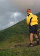
The trail was paved with natural stones that I believe designed to avoid erosion. Since it is raining the time I was hiking, the stones were wet and slippery. I noticed hikers on their way down with their wet raincoats on. I helplessly said "ni hau" (hello) to every one as that was the only chinese words I know aside from "tse, tse" (thank you). I wished I could say something more to hikers whom I met along but It's seems to be impossible at that particular time.

Cising Mountain stands the tallest at the rim of the Taipei Basin. Its main peak is 1,120m tall (above elevation). There was a crater at the peak but it became seven small peaks due to post-eruption erosion. The steep peaks of Cising Mountain are the most striking feature of this conical volcano.

Approaching the summit, there were strong winds blowing from almost all directions. Had I been not standing firmly, I have been blown away by the hard and heavy pushs of the wind. I hardly see anything except for that part of the trail which I was stepping at. Everything beyond 2 meters distance is not visible. I just grabbed some pictures of the peak and went down immediately. After almost three hours, I have returned to the visitors area where I came from. I had hot noodles treat for myself and a peep at some nearby hotsprings before heading back to the city.

Friday, May 22, 2009

Only in Macau


Macau, they say is a city with two faces. First, the fortresses, churches and food of its former colonial master Portugal speaks to a uniquely Mediterranean style on Asian coast. On the other, Macau is a self-styled Las Vegas of the East.

With more buildings on reclaimed land and diversity of its attractions, the greatest of these continues to be Macau's unique society. The ideas of East and West complementing each other, and the many people who come to visit - that, to most is Macau.


However, Macau to me is quite interestingly different even more.

1. You get to tour around Macau all day boarding a descent shuttle service free of charge.
2. You get to fill yourself of sumptous beef, pork and chicken jerky samples at Senado Square and the store staff could not care less if you if you ask for more everytime you pass-by their stores.
3. You’ll be delighted if store staff constantly give you pieces of almond cookies for free and still smile at you even if it’s your forth cookie of the day.
4. You get to speak to locals and understand each other, not by using the english language and them using cantonese but by using a simple calculator.
5. By 9 o’clock in the evening, you should be buying some early morning snacks because restos will open late the next day. Don’t be late...I’m telling you!!!
6. You get up in the morning, feeling that it is still early, not seeing any activity on the streets only to find out it is already 10 o’clock!
7. Yes, there are 7-11 convenience stores around. But nope, they are not open 24 hours!
8. You cannot possibly find a bath soap bar available even in popular stores. Believe me.


Thursday, May 21, 2009

P5K HK Backpacking: “been there, done that”


For most people, Hong Kong is one of the world’s most fascinating cities….a spectacular harbour, busy streets, bargaining vendors, fantastic architecture, active people….and so much more.

But few have discovered that, in contrast to all of the clamour that gives the city its buzz, it also offers some of the most tranquil, superb hiking and camping opportunities you will find in Asia.

Here are the activities that I personally devised and carried out last February 2009. Itinerary includes:

Round trip airport transfers
Welcome lunch and briefing
Transportation to and from the hikes
Overnight camping by the beach
Early morning assault to the Sharp Peak
1 night accommodation in a downtown hotel
2 bottles of water during the hike/camp
2 Snacks and drinks on the hikes
2 meals while camping
Sumptuous lunch at the city after hike
Outdoor shops tour
City Malling
Cocktail party celebration (optional)


I will be coming back to HK to do another Sharp Peak Adventure sometime soon. Those who wish to join may contact me by this blogspot.


Hiking in some remote areas always have some risks involved. I shall not be held responsible in any way for any injury or death incurred or any loss or damage to personal property caused due to whatever causes including, but not limited to, negligence, errors of judgement and inadequate orientation skills on my part. Joining this activity is an implication that you have agreed to and accepted unconditionally this disclaimer.


A gift @ Mt. Pulag


The 5-day weather forecast is distracting as we prepare our Mt. Pulag weekend climb. Arriving in Benguet, we were reminded to get as much water protection as possible. “It’s raining cats and dogs up there almost every afternoon”. This perhaps is another challenging climb as the last time we climbed the mountain about 2 years ago.

Requested by our friend who’s going to bid goodbye to singlehood. Arrived weeks ago with her Aussie fiancĂ©, we still pushed through with our plan.


Trailhead to the summit

I prepared my raincoat at the outer pocket of my backpack. Next to Ramon, our local guide, we started the long trek to the summit. I don’t have anymore rain protection other than my rain coat and my backpack’s raincover. Although previously informed of the weather condition, I chose to pack the lightest possible gear for the climb as I came from an intensive 10-day Advance Training Course of my beloved Scouting family at Mt. Makiling. Already exhausted serving as the trailblazer master for the participants’ anchor activity: the survival hike, I decided to use my 35L Jack Wolfskin’s lightpack. Tired and with little rain protection, I just crossed my fingers. “No rain, please....”
Started late and the annoying presence of late afternoon shower notices, notions constantly twiddled around my mind. I am not sure if I will ever catch Mt. Pulag’s sunset this time. And sunrise? Sana naman...meron.

We arrived at the campsite earlier than we expected. And there was not a single drizzle of shower extended to us by mother nature until we reached our destination. By night fall, it was a star studded night that I truly adored.
My colleagues prepared a feast: Seafood kare-kare, beef broccoli and iceberg beef salad. At 9 degrees and with chill factor temperature, we still enjoyed our dinner and a little cocktail celebration for the soon-to-be Mr. & Mrs. Maconahey.


Pulag’s sunrise


By 4am, we were up and begun our summit sunrise viewing. As I continuously stepped on the rocky ascending trail towards the summit, I remembered the exact feeling I had descending from them the last time I visited Pulag. All wet, with chills due to strong winds and the never ending rainshowers......the event seemed like madness. But here now, as I elevate my feet in every step I make going to the peak....... “My God, you will not let your child get disappointed this time”.


Thank you Lord for that wonderful morning. I felt I was the most blessed God’s child that time.


My Calaguas

A day after my birthday, relaxed and still enjoying the “slow down and chill out” idea of a celebration I again packed my stuff and head for another adventure....Calaguas.


At around 8:00pm Friday, when I usually end my day and retire, I instead went out with my stuff and catch the not so late bus ride to Camarines Norte.


It was my first ever trip to the region. I wanted to see what the countryside looks like but I could only see darkness from the pane of the bus’ glass window. I just closed my eyes and took a nap instead. By day break, as the sun slowly shed light, after almost eight hours of travel I looked out and checked: finally-- Daet.


Not knowing where exactly I was, I jumped out of the bus and just took a tricycle. “Padi, sa pandawan ng Vinzons”, the driver nodded and went at once. Just as we are arriving at the port (pandawan), one boat is about to undock. “Sandali, padi! Sasakay ako” And as soon as I hopped in the boat, I asked everyone: where are my friends? With no answer heard, somebody asked me instead: “saan ka punta?” “Mahabang buhangin, padi”. Ay, mali ka! Banocboc ito, sa pistahan” “ho?!, ay bababa po ako!” as I jumped out of the boat somebody shouted: “ sa Minaogan ka, padi. Dali, aalis na ang bangka don!”


Few but long leaps away from the pandawan, I already found myself at the side of the road waving for a passing tricycle and very swiftly, with my backpack still hoisted on my shoulder, I jumped at the backrider’s seat and said: “pasakay lang padi, nagmamadali ako.” Seconds after, I touched down Minaogan and saw my friends as the skipper removes the rope of the banca from the dock. Whoah......I did it exactly on time!!!!!


Two hours of banca ride and finally we reached Calaguas. A remote, unspoiled dwell where water is as blue as the clear skies and the sand....almost as fine as talc. Truly indescribable in words, to better understand it.....one should really see it. Any word to depict the place, I guess is an understatement.


Saturday, January 31, 2009

The Road To Tayak (as published March 2006)


Background

Mt. Tayak is located at Sitio Sto. Nino, Brgy. Tala, Rizal, Laguna. It stands EL. 687 m lies along the Northwestern foot of Mt. San Cristobal. It has an approximate area of 2.5 ha with steep slope of 20 to 35 degrees. On its North is Brgy Tala, Rizal, Laguna; South is Mt. San Cristobal; East is Brgy Taytay-Malaya, Nagcarlan, Laguna West is Brgy. Sta Elena, San Pablo City.


How to get there

Sitio Sto Nino to this date is the best possible access going to Mt. Tayak (there also exists Brgy San Diego route approx. 10 km). You can reach Sitio Sto. Nino by foot via Brgy. Tala, Rizal, Laguna route with approximate distance of eight (8) km and with rather gentle slope of 3 to 8 degrees. Upon reaching Sitio Sto. Nino, the slope of highland Mt. Tayak is 20 to 35degrees steep going to its summit.


How Mt. Tayak got its name?

Local people call it “parang”, a general term for wilderness. People from neighboring town Nagcarlan call it “tilos” due to its pointed shape. San Pablenos and numerous mountaineering communities however call it Mt. Tayak, named after a local vigilante popularly called “Bueno Tayak” who set foot and hid along the area after authorities hunt him for several alleged misdemeanors during the 1960s - 70s.
The municipality of Rizal which holds the location of Mt. Tayak is approximately 70 km southeast of Manila. Transportation going to Rizal is served by South Expressway going to San Pablo City. Rizal is situated along the National Highway that connects San Pablo City and the municipality of Nagcarlan.


Prior Development Issues

Mt. Tayak is a private land owned by the heirs of Jose Lucido where the whole area consists mainly of grassland. It used to be a pasture land managed by the owners themselves. Like all other lands on the upland areas, Mt. Tayak was thought to be unsuitable for farming partly because soil erosion starts to become excessive when land above 18 degrees slopes are cultivated. Due to strong winds, forest trees also cannot be grown on the entire area.

Decades ago, the owners ceased to utilize the area. No one among their children or grand children manifested interest on the said land. The area remains idle since then and up to these present times. Upland farmers also regard Mt. Tayak as worthless for land cultivation. However, few people appreciate the area as haven for those seeking solitude and tranquility. It is a place conducive for meditation and a respite from the hustles of the metropolis.


Present Condition of the Area

Like all other popular mountains around Philippines, the advent of outdoor recreational sports as mountaineering paved the way in the introduction of Mt. Tayak to outdoor enthusiasts. Several years ago, Mt. Tayak was noticed by some mountaineers passing-by coming to and from Mt. San Cristobal. Although the difficulty level of climbing Mt. Tayak is way, way short and easy compared to other popular mountain destinations, It was then regarded as a suited venue that can cater mountaineers, backpackers, hikers or our own boyscouts, even novices and non-mountaineers and just plain nature trippers.

Recent closure of Mt Banahaw to public visitation gave even more awareness of Mt. Tayak to be an alternative destination along the Laguna-Quezon area. These slowly lead the introduction of Mt. Tayak to people coming from different places. Its proximity to Manila and accessibility to public transportation makes it more inviting to visit.

view more pictures : monteza.multiply.com